
Mum and I set off to tackle the Mount Anne Circuit in Tasmania’s Southwest National Park – but would we make it past the notorious ‘Notch’?
A few years ago, we attempted to go up to Mount Anne in Tasmania’s Southwest but only made it as far as Mount Eliza before poor weather forced us to abandon our walk. The weather was looking good for the first week in 2017 so we packed our bags and headed off to try and complete the 3-4 day Mount Anne circuit. We left feeling a little uncertain whether we would make it all the way – we knew that the walk contained a decent amount of rock scrambling and was exposed in many parts. Even after talking to friends who had done the walk and reading several blog posts, it was difficult to gauge how hard it was going to be – some had said that it was ‘not too bad’, while others said it was ‘almost impossible’. There was only one way to find out….
Most of the photos on this post were taken by Mum.
Day 1: Condominium Creek car park to Shelf Camp via High Camp
6.7 km
The circuit starts at the Condominium Creek car park on Scotts Peak Road. We wanted to attempt the ‘circuit’ which comes out at Red Tape Creek car park, about 8 km further down Scotts Peak Road. I didn’t like the idea of plodding back along this boring and dusty road section after a few days of walking through the wilderness, so we stashed an old bike and helmet in the bushes at the Red Tape Creek car park before starting the walk from the Condominium Creek car park.
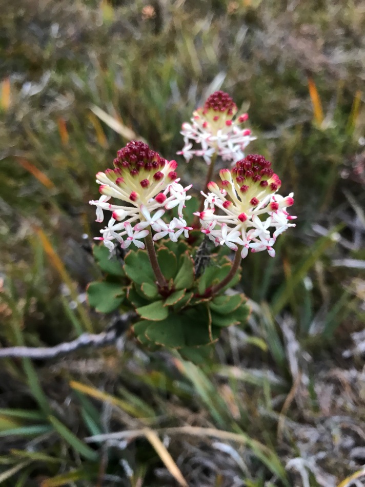
We left the car at around lunch time and climbed the steep steps up towards Mount Eliza. Below us, we could see impressive views of the flooded Lake Pedder. Clouds played around the crests of Scotts Peak and Mt Solitary, making them look like erupting volcanoes protruding from the flooded lake. We took it nice and easy on the climb up the steep steps, taking plenty of stops to catch our breath and admire the alpine flowers that were blooming on the sides of the track. Square wombat droppings were scattered periodically along the path, and Mum wondered aloud (as she often does) whether we might spot a wombat on the trip. After about 2.5 hrs of walking, we reached the small hut at High Camp. There is a toilet here and a few spots to pitch a tent. By this stage the clouds had rolled in and the views had completely disappeared. It brought back memories of our previous excursion here – sleeping in a flooded campsite and seeing zero views. I hoped that this time the weather would clear for us…


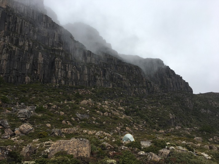
There were a few other groups already in the hut, and our legs had some energy left, so we continued up the hill towards Shelf Camp. We had heard that Shelf Camp was one of the best camp sites in Tasmania and we were keen to set up camp there. Soon after leaving High Camp the track leads to the first rock scrambling section which heads up to the top of Mount Eliza. Again, no views from here for us, but on a clear day I can imagine they would have been great! The clouds and mist did make it quite atmospheric though as we passed through the gorgeous tarns along the top of the Mount Eliza plateau. Another rock scramble over large dolerite boulders led down to the turnoff for the Mount Anne summit, where the weather cleared enough to give us our first glimpse of the cliffs of Mount Anne. We knew we couldn’t be too far from the camp site since we could hear the clanging of pots rising from the mist below us, and a group of boys yahooing – obviously they were also very excited to be having their first small glimpse of Mt Anne!
We arrived at Shelf Camp at around 6 pm and set up camp on one of the many rock slabs, and settled in for a cuppa, some dinner and an early night. The other party who were camped at Shelf Camp that night were walking the circuit in the opposite direction so they had already tackled ‘The Notch’ section. I was keen to hear how they had found it. They told us that it had been not a problem for them, but they were all experienced rock climbers – so again, it was hard to tell what the next few days held in store for us…

Day 2: Mount Anne return
About 3 km
We woke to another cloudy and drizzly day, with no views in any direction. We didn’t want to attempt any of the exposed rocky sections while it was wet, so we spent the morning reading and taking it easy at camp. At around lunch time, the clouds parted and we got our first full view of Mount Anne towering above us. Wow! We quickly packed our day bags and headed back up to the track junction and along the track leading to Mount Anne. With clear skies the view from the track was impressive, with views down towards Lake Timk and Lots Wife. We could clearly see the spectacular ridge leading out towards Mount Lot – our path for the following day. I would say that the track out towards Mount Anne is worth exploring even if you aren’t planning to attempt the summit.


The walk to the top of Mount Anne can also be done in a day from the Condominium Creek carpark. We passed a couple of day walkers who were returning from the summit as we were heading up. They had made it to the top, but warned us of the climb ahead, and wished us luck. After a clamber over more car-sized boulders we reached what first appeared to be the base of a series of small cliffs – the only things between us and the summit. An arrow scratched into the rock wall indicated the best way up and I pulled myself up the first section to test out the climbing. This section would be simple for experienced rock climbers, but provides a challenge for the average bushwalkers like us.


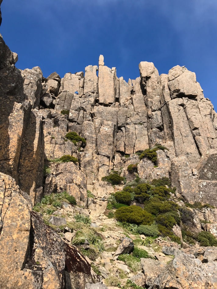
I returned to the base of the steep section and after a bit of ‘rock climbing practice’ on the lower section, Mum decided she would save her climbing legs for the next day. I was keen to try for the summit, so I clambered back up the crack and along a series of ledges to the left. The rock was still a little wet, and there was a decent fall if I were to have slipped so I took it nice and slow. I got up the next climbing section ok, although I wasn’t looking forward to coming back down! A few more sloping ledges led to the right, and as I rounded the corner I was faced with a fantastic view down into the valley and towards Lots Wife. The summit was not far off now, and from what I could see, the next section involved walking along a flat, but sloping, ledge before the final climb to the top. It looked very do-able but I have never been good with heights and the only thing I could see beyond the edge of the ledge was Lake Timks some 1000 metres below. With my legs starting to shake, I decided to turn back and return to where Mum was waiting at the base of the climb. I will save the climb for my next visit, perhaps when I have a friend there to help egg me on up the last stretch. As expected, the climb down was worse that the climb up. Some people might find a rope comforting when going up and down these sections. After tracking down Mum who had wandered off to take some photos, we retraced our path back to Shelf Camp.
Day 3: Shelf Camp to Judds Charm
3.9 km
We woke to yet another cloudy and wet day, so took shelter in the tent to read. Out of nowhere an explosive sound pierced the air. It took me half a second to work out what is was – and my stomach tightened a little when I worked it out… Shelf camp is sheltered from the weather on one side by a large wall of dolerite columns, and the sound that we were hearing was one of these monoliths breaking loose from the wall and plummeting down the hill towards us! Luckily nothing made its way down to the camp, but another party who were camped on a small knoll above us said they had seen the boulders tumbling down the hill towards us and shards of rock flying through the air. Well that was an exciting way to start the day!
With the heavy clouds and drizzle in the air (and our unsuccessful Mount Anne summit attempt on our minds) we didn’t like our chances of making it through the notorious Notch section so we made up our minds to return back to the car along the same track we had come. We were really not looking forward to going back down those steep steps! But just as we shouldered our packs, the clouds parted and we once again saw the magnificent ridgeline leading up to Mount Lot. We looked at each other – ‘Let’s give it a go’.

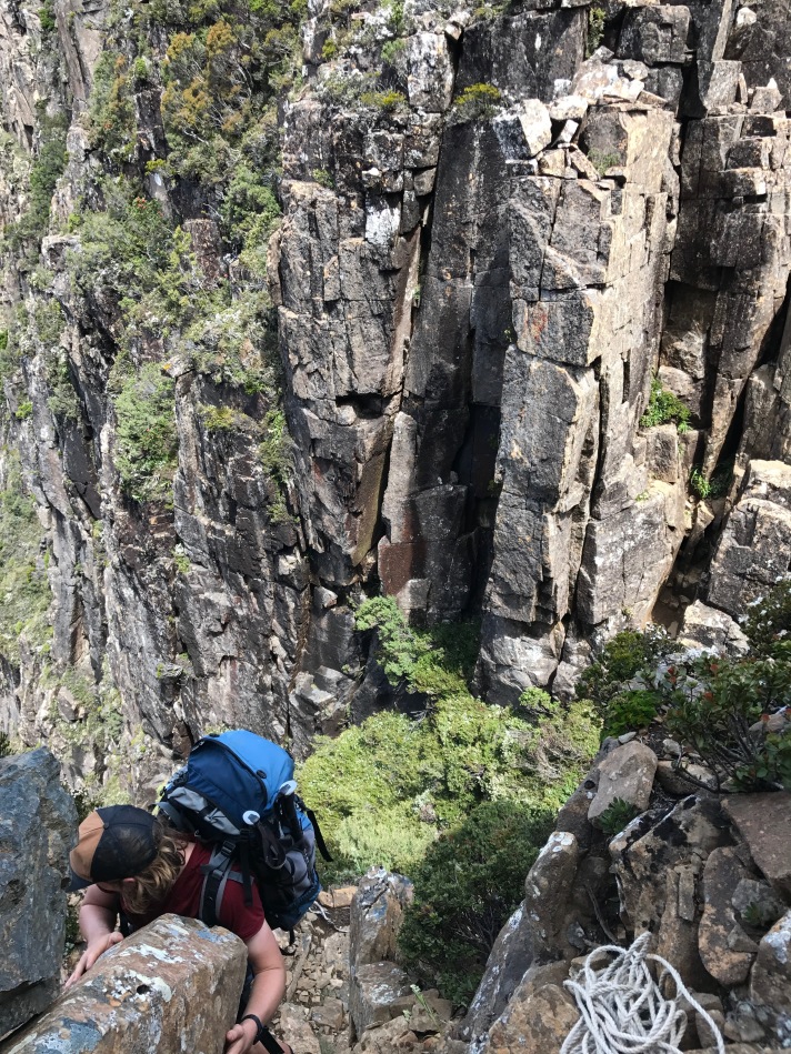
From Shelf Camp, the track passed a few small, beautiful tarns before climbing towards the ridge. From here we were rewarded with magnificent views down to Lake Judd and across towards the Western Arthurs and Federation Peak. It was definitely worth coming this far even if we didn’t make it past the Notch! From this point on the real rock clambering started as we made our way around to the Notch and Mount Lot. We used our rope once to lower our packs down a short, but steep, rock slab. We passed a family who had made it as far as the Notch but had felt too uncomfortable to continue. I wondered how we were going to go…


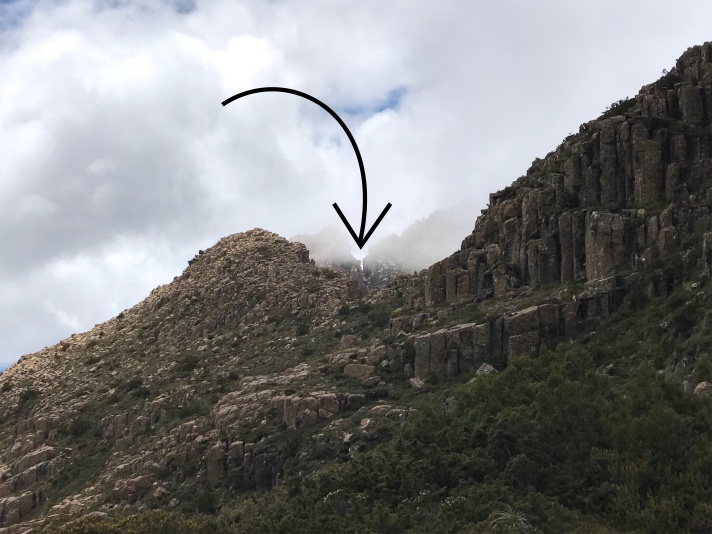
The Notch is appropriately named – it is as if someone had snipped a ‘V’-shaped nick into the steep ridge line. To get past this section, the track first drops down into the bottom of the ‘V’. I set up a rope to lower the packs down just to be safe. Standing at the bottom of the ‘V’, the ridge drops away steeply on either side. Using the rope might have been somewhat unnecessary since the climb down wasn’t too difficult, but we had just witnessed the party in front of us accidently drop their pack down from the Notch and have to clamber down a slippery, rocky gully to retrieve it. I didn’t want to have to do this too!
Standing at the bottom of the Notch I finally felt a little relieved – although we had a decent rock face to climb, I could see that there were several reasonable sized ledges to use. I made it up without difficulty – although I didn’t spend too much time looking down to my left, where the valley floor seemed quite a large way away. As expected, the ledges made for easy enough climbing, and I could pull myself up onto the last ledge. This was probably the hardest bit and required me being able to pull my body weight up onto the ledge without having too many handholds to hang on to. Once safely at the top, I set up a rope and hauled the packs up.
Mum did well to clamber up mostly unassisted, only needing to hang on to the rope on one section for a bit of extra security. Soon enough I saw her head pop over the top of the last rock ledge. She seemed to be smiling a little too much for a someone who was standing tip-toed on a very small ledge above a very large drop. With one last push we had both conquered the Notch! Woohoo!


After a bit of lunch, we continued along the track which skirts around the side, and then up towards the top of, Mount Lot. The views down towards Lake Judd and out over to the Arthurs were incredible, although we had to spend most of the time watching our feet to ensure we didn’t take a tumble down the steep slopes. I pulled out the rope a couple more times to help haul the packs up some steeper sections. This section definitely wasn’t a walk in the park, but we had a bit more confidence in our step having got past the Notch so we made it up to Mount Lot without too much hassle. From the peak, we got clear views that stretched across much of the state – from Precipitous bluff in the south, and north towards the mountains of the Overland Track.


I always find going down much more tiring, and this day was no exception. We could see a tent set up near Judds Charm – our campsite for the night – and it still seemed a fair distance away. We made our way down the ridge, clambering over more boulders, before dropping off the side of the ridge and into a section of beautiful forest. The vegetation here felt prehistoric, with the track winding down through towering Pandani and mazes of twisted tree trunks. Emerging at the bottom, we were treated with a most spectacular sunset as we made our way towards camp. A stunning end to a memorable day!


Day 4: Judds Charm to Red Tape Creek car park
11.9 km
My mind had been so occupied thinking about getting past the Notch that I had almost forgotten we still had to get back to the road. The combination of tired legs, bag-catching trees, knee-deep mud and scorching heat turned this day into a bit of an exhausting slog. But we enjoyed ourselves as we passed through the Lonely Tarns, explored the plateau behind Mt Sarah Jane and descended down the hill and back towards the car. At the bottom of the hill, the Mount Eliza-Eve Peak-Mt Anne massif was breath-taking.


I was not looking forward to the dusty ride back along the road. Luckily, soon after we arrived at the car park a group of day-trippers from the Hobart Walking Club appeared behind us and offered us a lift back to the car. Afterwards, we drove down to check out the campsite at Edgar Dam and enjoyed a cuppa and a swim on the edge of the flooded Lake Pedder, before heading back to Hobart. As we turned out of the carpark a wombat crossed the road in front of us – a fantastic way to end a great trip.


Overall, this circuit was an extremely enjoyable and satisfying trip. I would happily say that it was one of the best walks I have done anywhere in the world. Definitely not your average ‘walk-along-a-track’ kind of bushwalk, but if you are happy to do a bit of rock scrambling then I would highly recommend putting this on your ‘to-do-next’ list.
Useful Resources:
Maps TASMAP 1:25,000 Anne, Scotts
‘South West Tasmania’ by John Chapman
http://sonsofthedesert-abushwalkingblog.blogspot.com.au/2014/01/mt-anne-circuit-success-at-last.html

Thank you for sharing this. I’ve done numerous days walks up Mt Anne, I’ve just come back from another summitting yesterday, but haven’t been game to go further on my own. After reading your great walk notes and your fantastic photos I feel I must bite the bullet and do the circuit. What sort of camera do use use? You have a good eye for a great photo.
LikeLike
Hi Marian. Sorry, I have only just seen this comment now. Maybe you have done the circuit by now? Most of the photos were actually from an iPhone, but I did also have a Nickon D1000 on this trip. Many of the photos were actually taken by mum – she has a good eye for photos. Thanks for the feedback.
LikeLike
Amazing! I’m not sure whether to be inspired or terrified. A bit of both! Beautiful photos. Thanks for sharing.
LikeLike
Hi Jen. Yes a beautiful part of the world! Don’t be terrified, be inspired!
LikeLike